Wet Snow in the Alps
Optical sensors can see snow clearly in the absence of clouds, but they are not able to differentiate between dry and wet snow. C-band radar sensors like on the Sentinel-1 satellites, provide an extra layer of information: the signal can look through clouds and the backscatter they receive is modulated strongly by wet snow, while dry snow is often nearly transparent. Mapping wet snow is important, as a) it feeds into avalanche prediction models, and b) snow-laden mountains provide a source for drinking, irrigation or hydroelectric power.
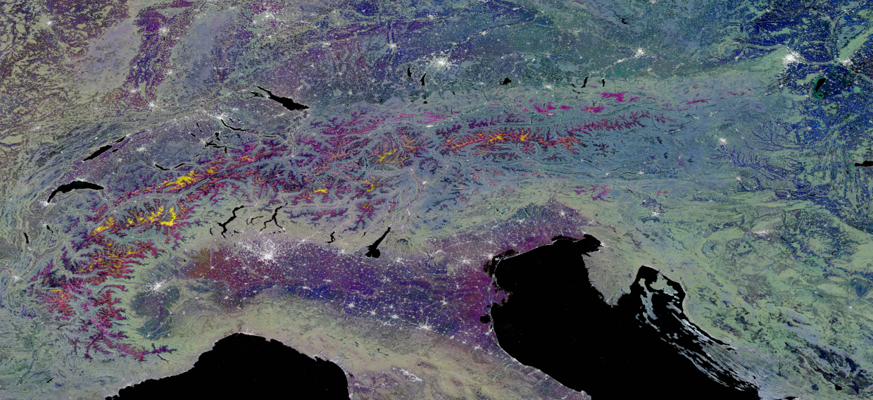
At the University of Zürich, researchers are using the SAR (Synthetic Aperture Radar) backscatter signal to quantify the evolution of snow cover. Alpine snow melt is visualized through Red-Green-Blue (RGB) overlay of three processed Sentinel-1 backscatter composites; each color channel corresponds to the following 12-day date ranges—Red: 01.25-02.05.2017, Green: 01.-12.04.2017, Blue: 18.-29.06.2017. The yellow mountain tops can be interpreted as follows: the snow on these high mountain tops was dry on the first two dates (Jan + April) and backscatter to the instrument was high (light comes back) resulting in high red and green numbers when displaying as RGB image. In June, the snow was mostly wet snow resulting in low backscatter and thus low values for the blue channel. At the very mountain tops snow stayed dry and is thus represented in white in the image. Urban areas have always very high backscatter (white) and water always very low (black).
Source: Modified Copernicus Sentinel-1 data (2017) and modified text from Small et al, 2022: Wide-Area Analysis-Ready Radar Backscatter Composites
Are you interested in this topic?
At the University of Zurich, several researchers are actively studying SAR technologies. See howDr. David Small, andDr. Elias Mendez at the Department of Geography research in the domain of SAR technology as part of the research group Remote Sensing of Water Systems.
Are you a student that wants to learn more about this topic? Consider enrolling in these courses:
GEO 233: Remote Sensing and Geographic Information Science III (Basics of Remote Sensing)GEO 371: Remote Sensing and Geographic Information Science V (Remote Sensing Methods)GEO 442: Advanced Technologies and Methods in Passive Remote Sensing
GEO 443: Advanced Technologies and Methods in Active Remote Sensing